Tropical Storm Sara forms, with a turn toward Florida still possible
Published in Weather News
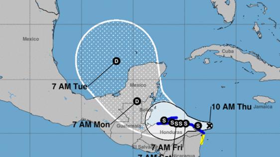
FORT LAUDERDALE, Fla. — Tropical Storm Sara formed in the western Caribbean Sea Thursday afternoon as it headed toward Honduras, but there is a great deal of uncertainty about what, if any, impacts the storm will have in Florida or other parts of the U.S. Gulf Coast.
As of Thursday afternoon, Sara was located off the coast of Honduras and was slowing down while gaining strength. It could continue to intensify before interacting with land.
From there, the forecast track is unclear. Long-range forecast models, known as “spaghetti models,” have indicated a turn to the northeast and toward the Florida peninsula. But interaction with land could significantly change those models over the weekend.
For now, the National Hurricane Center is advising residents in Florida, the Keys, and other parts of the Gulf coast to regularly check the status of the storm. The National Weather Service Miami said in a Thursday morning update that the storm currently poses no threat to South Florida, but “uncertainty remains high past Day 5.”
Bryan Norcross, hurricane expert for Fox Weather, wrote on his blog that “if the system maintains a core and decent structure during its time over land, there is plenty of warm water in the southern Gulf for it to reorganize and strengthen before it reaches Florida, if it heads that way. Seawater in the northern half of the Gulf is much cooler.”
AccuWeather lead hurricane expert Alex DaSilva said in a release that the storm could take a northeastward turn early next week and potentially bring impacts to parts of Cuba and Florida. Heavy rain is expected across Jamaica and parts of Haiti for the next few days.
“All of the conditions are coming together to allow this storm to intensify rapidly. There is plenty of moisture, low wind shear and very warm water temperatures. We don’t see any obstacles that could prevent this storm from exploding into a major hurricane,” said DaSilva.
DaSilva also noted low wind shear in the western Caribbean in the next 10 days.
The cyclone is the Atlantic Basin’s 19th tracked system of the 2024 season and, if it becomes a hurricane, will become the 12th of the season.
As of 1 p.m. Thursday, Sara was located 205 miles east-southeast of Isla Guanaja in Honduras. It had maximum sustained wind speeds of 40 mph and was traveling west at 12 mph. Tropical-storm-force winds extend out 70 miles from the center.
Honduras issued a tropical storm warning from Punta Sal east to the border with Nicaragua and for the Bay Islands.
Nicaragua has issued a tropical storm watch from the Honduras/Nicaragua border southward to Puerto Cabezas.
Hurricane conditions are possible within the watch area by Friday, the hurricane center said.
The system “is expected to stall and meander near the north coast of Honduras late Friday and through the weekend,” the hurricane center said in its latest advisory.
Forecasters said 10 to 20 inches or rain could fall in the region, with isolated storm totals around 30 inches in northern Honduras. Large amount of rain in mountainous areas could result in life-threatening and potentially catastrophic flash flooding and mudslides, much as they did in North Carolina during Hurricane Helene.
The storm will likely continue to develop while it meanders over the western Caribbean Sea toward the Yucatan this weekend. If the system remains over water, it could strengthen significantly, but if it moves over Central America, it would weaken.
A sharp enough turn would cause it to miss Florida altogether, and a broader turn would send Sara into Florida’s Gulf coast.
Hurricane season runs through Nov. 30.
©2024 South Florida Sun Sentinel. Visit at sun-sentinel.com. Distributed by Tribune Content Agency, LLC.


Comments